Cocoa Beach in the 1950s, before NASA arrived
What the barrier island looked like the decade before the astronauts: a fishing community of a few hundred people, one paved road, a wartime airbase next door, and zero idea what was coming.
The 1950 federal census recorded 246 people living in incorporated Cocoa Beach. The 1960 census, ten years later, recorded 3,475. That fourteen-fold jump is the entire story of the decade: a quiet fishing settlement with one paved road and a few dozen oceanfront cottages turned into a satellite town for a missile-testing range that hadn’t existed in 1949. Almost everyone who actually lived in 1950s Cocoa Beach saw the entire transition happen between their porch and their mailbox. Most of them are gone now, and the Florida Memory oral-history archive holds maybe two dozen surviving voices describing what the place was before NASA.
This piece reconstructs the decade from those voices and from the documentary record: who lived there, what they did, how they got from the mainland, what they ate, what they fished, where they bought groceries, and what the day Patrick Air Force Base opened across the south town line actually changed.
The geography, as residents experienced it
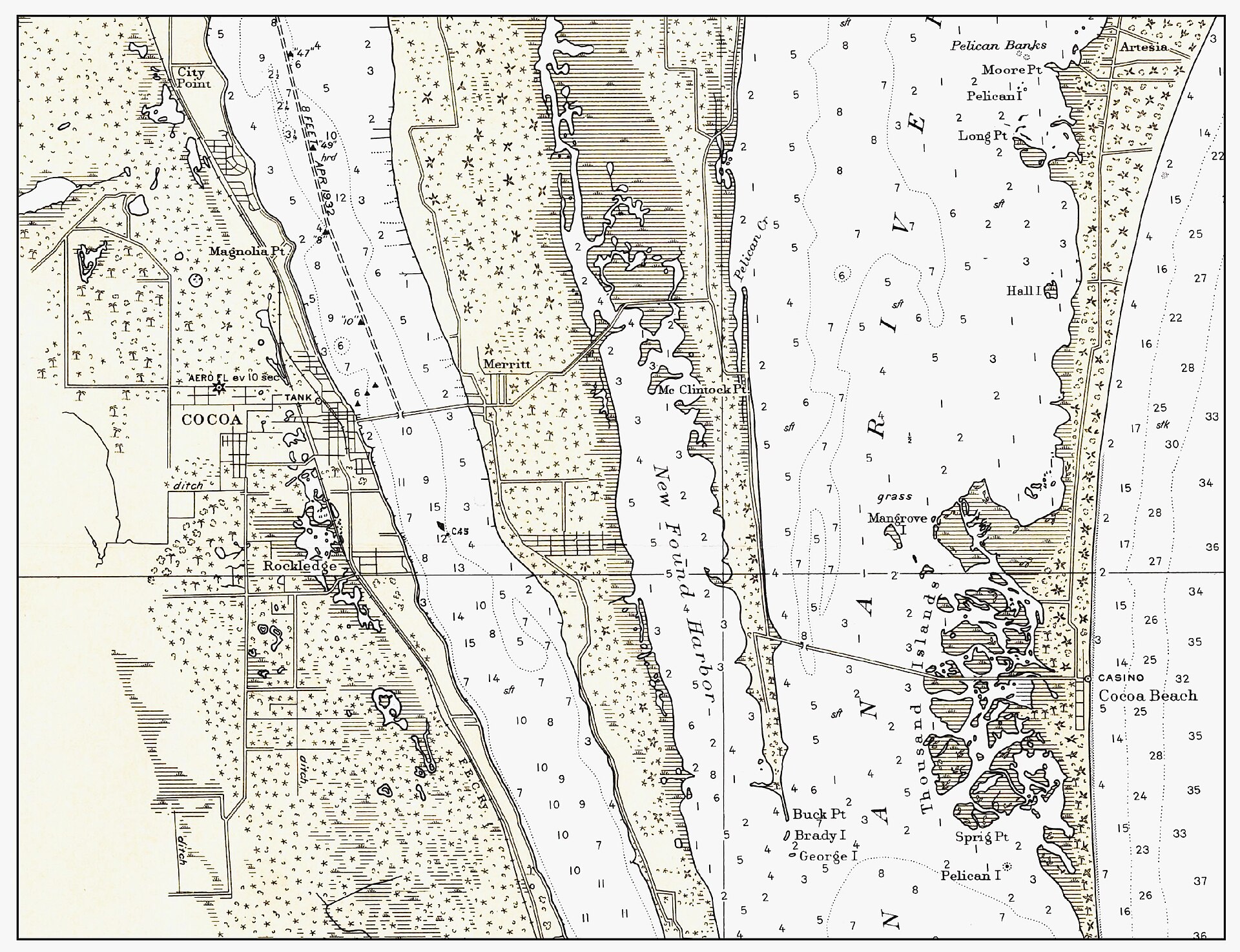
The Cocoa Beach barrier strip in 1950 was a few miles of sand, palmetto, sea grape, and Australian pine, running north-south between the Banana River and the Atlantic. The strip was one-mile wide in most places. The Atlantic side held the beach; the Banana River side held mangrove and brackish marsh. The middle held the road.
State Road A1A, the spine of every later development, was a two-lane asphalt strip in 1950, paved in the 1930s and 1940s in segments. South of Cocoa Beach proper, A1A ran past the Banana River Naval Air Station (commissioned 1942, deactivated briefly after V-J Day, reactivated in 1948), then south through what would later become Patrick Air Force Base, then on toward Melbourne.
There was no causeway connecting Cocoa Beach to the mainland Cocoa across the Banana River until the construction of the State Road 520 bridge, which opened in segments. By 1950 you could drive across; before then, residents and visitors had taken a boat. The bridge changed everything before NASA did. Without a road across the river, no commercial development was possible on the strip; with it, a 1950s buyer in Cocoa or Rockledge could own a fishing cottage on the beach and use it on weekends.
Who lived there
The 246 residents of 1950 Cocoa Beach were, broadly, four overlapping groups.
Commercial fishermen and their families. A handful of households worked the Atlantic out of small boats based in the Banana River or out of beach launches. Catches included Spanish mackerel, snook, redfish, and seasonally mullet. Some sold to mainland fish houses in Cocoa; some sold directly to the few Cocoa Beach restaurants that existed. This was a working-class community in 1950s terms, and the houses were small, wood-frame, often on raised pilings against storm tide.
Winter retirees and weekenders from the Northeast. A small number of Cocoa Beach lots had been sold during the Florida boom of the early 1920s to Northeastern buyers, and a slow trickle continued through the 1940s and 1950s. These were often modest cottages used a few months a year, owned by people who lived primarily elsewhere. Some were converted to year-round occupancy as their owners retired.
Year-round residents from Brevard County mainland. A meaningful fraction of the 1950 town was Cocoa or Rockledge families who had moved across the river for cheaper land, easier fishing, or the beach itself. These were often working-age adults with regular jobs on the mainland (the citrus industry, retail, government) who commuted daily.
A few descendants of the early Black settlers. The freed-slave families who had owned barrier-island land since the 1880s had, by the 1940s and 1950s, mostly lost their parcels through the tax-sale system or to forced sales. A few descendants remained in or near Cocoa Beach, though the documentary record on this point is thin and the city’s published history doesn’t dwell on it.
Combined population was small enough that residents knew each other by name. The single school-aged demographic too small to support its own school: Cocoa Beach kids in 1950 went to school in Cocoa, riding the school bus across the Banana River bridge.
The commercial strip, such as it was
A handful of businesses operated in 1950s Cocoa Beach before the astronaut boom. A small grocery store, a couple of fish restaurants, a beach motel or two, a gas station, a hardware store of sorts. The classic Cocoa Beach mid-century motel architecture, the neon-lit, cinder-block, kidney-pool, “Modern” pieces that boom into existence in the 1960s, was not yet here. It was almost entirely a wartime-built or post-war-built cluster of small commercial structures along A1A, catering to local residents and the small flow of fishing tourists.
Bernard’s Surf, the most famous restaurant in 1960s Cocoa Beach, didn’t open until 1948, and it ran for several years as a small seafood and steak place before becoming the astronaut hangout that made it famous. The Cocoa Beach Pier, which would open in 1962, didn’t yet exist; fishermen worked from the beach, from skiffs, or from a few small private docks on the Banana River.
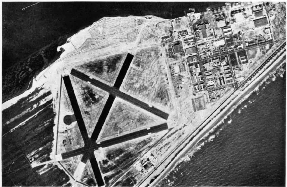
Patrick Air Force Base, the inflection point
The Banana River Naval Air Station had operated through World War II as a patrol-aircraft base, primarily flying anti-submarine missions over the Florida coast. After the war it briefly closed, then reopened in 1948 as a Navy facility. In 1950 it was transferred to the U.S. Air Force, renamed Patrick Air Force Base (after Major General Mason Patrick), and assigned a new mission: support the new Joint Long Range Proving Ground at Cape Canaveral.
That mission is the inflection point. Cape Canaveral, an Air Force-managed missile-testing range, began operating in 1950, with the first missile launch (a German-derived Bumper-WAC) flown the previous summer in 1950. Patrick AFB grew steadily as the launch program grew. By 1955 Patrick had a thousand-plus military personnel and a much larger civilian contractor population, and the contractors had to live somewhere.
Cocoa Beach, with its 1925 charter, its A1A spine, its empty platted lots, and its proximity, was the obvious answer.
What changed first
Between 1950 and 1955, the visible changes were modest: a few more houses, a few more rentals to defense contractors, a slow uptick in lot sales. The Cocoa Beach motel building boom hadn’t started yet. The big change was demographic, the median age of the population dropped as working-age contractor families arrived, and the median household income rose as defense salaries replaced fishing income.
Between 1955 and 1960, the visible changes accelerated. The first significant motel projects opened. Restaurants expanded. A1A got more traffic. The town hired its first dedicated police force (a single officer, then two). New schools opened on the mainland Cocoa side to handle the population boom, and Cocoa Beach started lobbying for its own elementary school.
By the 1960 census, the population was 3,475. The town had gone from a fishing community to a contractor suburb in a decade, and the next decade, the Mercury and Gemini and Apollo decade, would be ten times more dramatic. None of the original 1950 residents could have predicted any of it. Most of them, talking to oral historians twenty years later, said the same thing: nobody saw it coming until it had already happened.
Further Reading
- Florida: A Short History by Michael Gannon
- A Land Remembered by Patrick D. Smith
- Cape Canaveral by Ray Osborne
Sources
- City of Cocoa Beach, official history, cityofcocoabeach.com/197/History
- Patrick Space Force Base, base history, patrick.spaceforce.mil/About-Us/History
- Florida Memory Project, Brevard County oral history collections, floridamemory.com
- U.S. Census Bureau, decennial census 1950 and 1960, Brevard County tables
- NASA history office, “The Cape Canaveral Story”, nasa.gov/history
As an Amazon Associate we earn from qualifying purchases.